FORMS AND STATURE CRYSTALS

Forms crystals
The shape of each crystal is not samasatu against the other, but the crystals have a wide variety of forms. Crystalline form is perwujutan all crystal planes that have the same relative position to the areas of symmetry or axes of symmetry.
There are 3 forms of crystals, namely:
1. The basic form (singular), is a crystalline form in which all the existing field has the same relation to the axis of the crystal, except the prisms where the plane perpendicular to the c axis; base field is not taken into account.
2. The form of the combination is a combined form of one or more of the forms of different basis that will form a new shape. The new form is the result of the combination.
3. Form a twin crystal form consisting of two or more of the same form which would be a new form.


Stature Crystals
Many minerals have a perfect crystal form, when in its formation there is any disturbance. In the wild are rare forms of perfect crystals, for it used the term stature crystals. Crystal stature means the typical shape of a crystal is determined by the built areas, including the size of the crystal. Wake of a crystal shape really looks not perfect shape crystal owned it since in the wild in the state of the crystalline and amorphous group.
As mentioned above, the crystal stature is not a fixed crystal characteristics, because its shape is strongly influenced by environmental conditions during crystal formation occurs. Nevertheless been known that the crystal stature often seen in certain types of minerals, so that stature is also a hallmark crystals that can be used in the determination of the type of mineral.
The terms for the determination of crystal physique that is widely used is divided into 3 parts, among others:
1. The term for solitary crystals:
a. Capillary (become like hair), such as hair.
b. Filliform (fibrous), like a thread.
c. Acicular (menjarum), such as needles.
d. Bladed (membilah), such as a knife.
e. Tabular (memapan), such as books; flat.
f. Lamellar (layering), such as layered.
g. Foliated (mendaun), like leaves; thin sheets.
h. Plumose (membulu), like a feather.
i. Blocky (membata), such as bricks.
j. Columnar (meniang), such as a pole; column / pillar.
2. The term for clustered crystals:
a. Columnar (meniang), groups such as masts.
b. Bladed (membilah), like a bunch of wooden planks.
c. Fibrous (menyerat), as sekelompo fibers.
d. Recticulated (capture), such as a net or network.
e. Divergent (scatter), like a fan.
f. Radiated (menjari), such as fingers.
g. Stellated (starred), like a star.
h. Dendritic (mendendrit) like a tree.
i. Collorm (rounded-round).
3. The term for crystal-shaped round.
a. Batryoidal, such as fruit menteng / wine.
b. Reniform, such as the kidneys.
c. Mammillary, bleak breasts.
d. Globular, like a ball.
e. Granular, such as granules.
f. Pisolitic, such as peanut granules.
g. Oolitic, just as fish eggs.

Besides the above terms, of course, there are other terms that are similar, or other division by categories. It is still possible because the source is different.

Structure of Crystal Axis
In addition to determining or measuring the angle of the field of two large, then to be able to imagine the crystal shape we must also determine the position of the field-field coordinate axis arrangement.
In the known crystal there are seven kinds of arrangement of the different axes remember three things, namely:
The number of axes.
Judging from its axis otal there are 2 kinds:
a. Consists of 3 axis is the axis a, b, and c.
b.Terdiri of 4 axis is the axis a, b, c, and d.
The angle formed by the axis.
Viewed from the angle formed by the axis, there are 4 kinds, namely:
a. Three mutually perpendicular axes (90º).
b.Empat axis, 3 axis which lies in one plane and mutually angled 120º, being the fourth axis perpendicular to the axis of the last three.
c. Three axis, where the axis perpendicular to the other two axes. Being the last one to two axes are mutually angled between 90º and 120º and contained in one plane.
d. Three intersecting axes make an angle of more than 90º.

Parameter / unit length of the axis.
Judging from the parameters, known there are 3 kinds, namely:
a. Three axis with the same parameters.
b.Tiga axes with different parameters.
c. A single axis with different parameters with two or three other axes.

Crystal System
Based on the composition of the crystal axes that have been described above, then the world known crystal 6 (six) crystal system, namely:
1. The regular system / isometric / cubic.
This system consists of a three-axis arrangement axis having the same length and all three mutually perpendicular (a = b = c and a ┴ b ┴ c).
2. tetragonal system.
Consists of three axes where the two axes of equal length and perpendicular to one another, while the third axis or the c axis perpendicular to the axis had different lengths (a = b ≠ c and a ┴ b ┴ c).


3. hexagonal system.
Consists of four axis where the three axes have the same length and form 120º angles lie in one plane, while the fourth axis as the vertical axis and perpendicular to the axis of the other three had different lengths. The fourth axis is often called the c axis (a = b = d ≠ c and a, b, d ┴ c).
4. System ortorombis.
Consists of three axes with different length but the three mutually perpendicular axes (a ≠ b ≠ c and a ┴ b ┴ c).
5. monoclinic system.
Consists of three axes with different length, while the b-axis perpendicular to the axis of the other two, but the axis a is not perpendicular to the c (a ≠ b ≠ c and a ┴ ┴ b b and c).
6. System triklin
Consists of three axes with different length, whereas the angle formed by the third axis is not perpendicular different also.

Crystal Field Symbols
Crystal axes are straight lines that penetrate the center of the crystal. Its position is determined by the symmetry of the crystal. The crystal axes have parameters (unit of length) that can be the same or different. The parameters required for the calculation of the position of a crystal field.
For ease of illustration, the crystal field given symbol consisting of a series of round numbers and figures that show how the intersection of the field relative to the crystal axes.
In the literature there are various ways of writing the symbol of the crystal field, such as: Weiss, Miller, Nauman, Dana, and Goldschmidt.

According to Weiss in symbolism should not be any fractional number, then rounded to 2a: 3b: 6c. Meanwhile, according to Miller (Miller indeces) for ALM field will be:

1/1 A: 1/1 ½ b: 1/3 c then equated the denominator, becomes: 3/3 A: 2/3 b: 1/3 c. So that was written by Miller is the numerator is (321).

MINERALOGY

Mineralogy is the study of minerals in the form of elements and compounds found in nature and is forming the solid parts of the universe. Mineralogy is not only limited to the materials of the earth's crust, but there are also from outside the earth, and based on geophysical measurements provide an indication of some of the properties of minerals contained under the crust.
Mineralogy is the branch of geology, because it is a rock-forming minerals of the earth's crust, Chemistry is also closely related to mineralogy, because the mineral is a chemical compound. The outer skin of the earth is called the crust, composed by solids that everyday we call rock. While the rocks are all kinds of materials that make up the earth's crust, and is an aggregate of minerals that have been hardened. Generally, a concoction some minerals rock.
Therefore mineralogy is the study of minerals, then we begin with a clear understanding of the mineral. To formulate a precise definition of the mineral in fact quite difficult. However, the mineral can be defined as follows: Minerals is a homogeneous solid objects found in nature, formed by inorganic, have a chemical composition on certain limits, and having the atoms are arranged in a regular
Mineral is a homogeneous solid body, it is stated that the mineral is composed of solid phase, only one kind of material that can not be broken down into compounds simpler by a physical process. With these requirements, then the liquid gas mapun excluding minerals.
Restrictions contained in nature is very necessary, because the chemical laboratory can be made a lot of minerals. For example, is the result of the evaporation of a solution of sodium chloride in the form of crystals that can not be distinguished from the mineral halite, also manufacture gemstone / accessories for commercial purposes, and so on.
Limitation that the mineral formed an organic-meaning that the mineral has a homogeneous solid objects generated instead of animals, plants and humans. However, do not eliminate the possibility of the presence of organic compounds as minerals. Many such substances, for example solid hydrocarbons, calcium oksulat been found in pet and coal; but is the result of burning natural distillation.
The requirement that the chemical composition of the mineral has a certain limit means minerals are chemical compounds, and chemical compounds that have a composition in certain limits are expressed in a formula either simple or complex. It depends on the number of existing elements and proportions combination.
Then another requirement is to have the atoms are arranged on a regular basis is a measure of the state of crystallization which can be seen in the picture outside. Position atoms in minerals according to certain rules, such as the mineral halite (NaCl) in which each atom of Na and Cl respectively surrounded by fields of eight by six Cl atoms and Na. While substances are not crystaling such as glass  nature, there is no regularity as mentioned above substances belonging to the amorphous substances.

Crystallography

Crystallography is the study of images of the crystal. Each type of mineral is not only composed of certain elements, but also has a particular form called crystal form. Crystalline form various patterns but always polieder or field a lot.
In the rare natural crystalline minerals ideal, the possibility dijumpa not in crystalline form but called crystal; For regular atomic arrangement. Proving it can be done with X-rays. Minerals that will be investigated given x-rays and minerals mounted behind the portrait sensitive paper. Thus the sheet of paper portrait will provide images. If the picture is regular and symmetric then the crystalline mineral, but if it does not say not so crystal.
Crystal is a solid object or substance that is homogeneous with the surface consists of flat areas formed by atoms or molecules are arranged regularly. Regularity properties of the composition is reflected by the outer face of the crystal that consists of flat areas. Complete crystal face is a polieder, and always limited by flat areas called fields crystal with a certain amount.
Minerals that crystallize bounded by areas together form the field much typical for a type of mineral. Regarding large crystals or crystal boundary wake there may be a triangle, rectangle, hexagon, and others-others are not so important. But most important is the angle field of two or polieder pivot angle of the crystal. Turns angle field two of each type of crystal is always fixed, this law we refer to as the Law of Steno (legal statutes two field angle). An example is the apatite crystals in which the angle between the x and m always at 130 ° 18 '. Two field angle measurement between x and m are using a goniometer or contact goniometer (reflectie goniometer).


Structure, process and stadia are important factors in the discussion of geomorphology. Discussion of a region is not complete if one of them is not dealt with (ignored). In the preceding discussion, it has been noted that three factors are known as the basic principles of geomorphology, whereas in this portion will be clear again, how the meaning and position of these three factors in the study of geomorphology.
1 Structure
To learn landscape form a region, then the first thing to note is that the geological structure of the area. As already noted, that the geological structure is an important factor in the evolution landscape and it is reflected in the structure of the earth, it is clear that landscape an area controlled / controlled by geological structures. In addition to the geological structure, are the properties of rocks, among other things whether the rocks are fractures (stocky), presence or absence of the field layer, fracturing, friability, porosity and permeability properties of rocks from one another.
According Thornburry, that understanding the structure of the geomorphology has a wider sense, while Lobeck distinguish between "Structural Geology" and "Structure Landscape". Some term geological structure: horizontal structure, dome structure, fracture structure, structure folds, volcanic structures; Some of the term structure landscape: plains or plateaus, hills dome, mountains faults, folds mountains, mountain complex. Because the structure is determined by the structure landscape geology, where the geological structure occurs by endogenous force, the structure can be interpreted as a form landscape landscape caused by endogenous style.
2 Process
Many experts, such as Worcester, Lobeck, and differ in interpreting Dury on the definition of geomorphological processes, they assume that what is meant by the process here is a process that comes from within and outside the Earth (endogenous processes and process eksogenik), some are thought process here is the energy that comes from outside the Earth (exogenous force) only. The notion here is energy process that works on the earth's surface that come from outside the Earth (exogenous style) and not from the earth (endogenous style).
Definition of "geomorphic Processes" solely inspired by the energy / process derived from
extraterrestrial, the reason is:
1. The energy comes from the earth (endogenous style) is more likely as a factor that builds, such as the formation of plains, plateaus, mountains dome, mountain folds, faults mountains, and volcanoes.
2. The energy of extraterrestrial origin (exogenous force) is more likely to change the shape or
landscape structure.
Style damage that causes any stage phases or "stages" on every kind landscape. Stage or stage is not caused by endogenous style like diastrophisme or vulcanisme.
Undeniably, that is both stylish (endogenous and exogenous), which is also known as endogenous processes and process eksogenik have a dominant influence in the formation of a specific landscape on this earth, therefore the genetic history landscape divided into two major categories yes it is:
1. Landscape contruksional, ie all landscape formed by style
endogenous (exogenous force has not worked here, so it is still at the initial level).
2. Landscape destruksional, ie all landscape formed by exogenous force against landscape generated by endogenous style, through the process of weathering, erosion, abrasion, and sedimentation.
Thus it can be explained that the definition of prose here is all the styles that affect the destruction (recast) landscape form resulting from endogenous style allowing landscape experience stadia Young, Adult, and Elder. Landscape reform process occurs through the river (fluvial processes), glaciers, waves, and wind. All four were referred to as dynamic agents (mobile agents / geomorphic agent) because they can erode and transport materials in the earth and then precipitation in certain places.
.3 Stadia
Stages / levels landscape (wheel geomorphic) declared to know how far the level of damage that has occurred and the stage / stage what landscape condition today. To state levels (treadmill geomorphic) used the term: (1) Young, (2) Adult and (3) Old. Each level in the geomorphology characterized by certain traits specific, not determined by age landscape

Relief of Earth


Relief earth is meant here is covering a very broad sense, both found on continents or oceans contained bottom. Based on the broad sense, the relief of the Earth can be grouped into three major categories, namely:
1. Relief Order I (Relief of the first order)
2. Relief Order I I (Relief of the second order)
3. Relief Order III (Relief of the third order)
The grouping of the three types of relief above is based also upon occurrence of each.
Hence it contains elements relative time.

1 Relief Order First
Consisting of Exposure Continent (Continental Platforms) and Ocean Basin (Ocean Basin). The forms of the first-order this includes a very large dimensions on earth. As we know that water and its land area totaling 107 million square miles, which consists of a vast continent (continents) amounted to 56 million square miles and the rest is 10,000,000 square miles wide from the edge of the continent (continental shelf). What is meant by Exposure Continent include Continental and Continental Bank. Thus the total exposure Continent is 66 million square miles. Exposure to North and South Americas, Eurasia, Africa, Australia, and Antarctica is the Courant-highest portion of the surface of the lithosphere.
The edge of the continent is part of the continental shelf which is located below sea level. Ocean basin has an average depth of 2.5 miles below sea level, although we know that the topography of the ocean floor has an irregular shape. There are a lot of very deep depression of average depth limit, known as the Sea Trench (Ocean Troughs), besides that there are also parts of the seabed which appear on the surface or gradually being close to the sea surface.
Relief of the first order is known to be closely related to the occurrence of the earth, thus theories of geology, astronomy, physics and mathematics, such as "planetesimals Hypothesis", "Spreading seafloor Hypothesis" and "Continental Drift Theory" became an integral part in the formation of relief of the first order.
.2.Relief Second Order
Relief Order two commonly referred to as forms that build (Constructional forms), this is due to the relief of the second-order formed by endogenous style as a constructive force. Area of ​​the continents and the ocean puddles where the presence or formation of units of the reliefs of the second order, such as Plains, Plateau and Mountains.
3. The shape of the energy generated by ocean waves, namely:
a. Erosional forms, such as: erode sea caves
b. Residual forms, such as: staoks & Arches
c. Depositional forms such as: beaches, bars and spits
4. Form created by wind energy, namely:
a. Erosional forms, such as: blow holes in sandy areas
b. Residual forms, such as: pedestal and mushroom rocks.
c. Depositional forms such as sand or clay sediment in the form of dunes or loess.

In addition to the energy of the physical damage, the organism can also be an agent that tends to destroy the rocks in the earth's surface, otherwise the activity of precipitation can produce forms such as coral reefs (coral-reefs) and karst. It can be concluded, that the time of formation of the third-order relief is different. The first form of relief is formed ahead of the second-order relief and relief of second-order form ahead of the third-order relief

To learn geomorphology required a good knowledge base in the field of climatology, geography, geology and some physics and chemistry which is closely related to the process and the formation of the earth. Broadly speaking, the process of formation adheres to the principles of sustainable earth in the form of geomorphic cycle (geomorphic cycles), which includes the establishment of land by force from the earth (endogenous), the process of destruction / weathering due to outside influences or exogenous force, the deposition process of the results demolition earth (gradation), and resurfaced as endogenous energy, and so on is a geomorphological cycle is in a very long time scale.
1. Processes and the same physical laws work now, work is also in the geologic time ago, although the intensity is not the same as it is now.
2. The geological structure is the dominant controlling factor in the evolution of the form
landscape and geological structure is reflected by the shape landscape.

3. The difference between the face of the earth that is different from one another due to the degree of
different formation.
4. Processes geomorphology leave scars that real in any form landscape and geomorphological processes will build a certain characteristic in the form of landscape (leaving a trail-specific and can be distinguished clearly by another process).
5. Due to differences in erosion force acting on the surface of the earth, then produced an order form landscape that have certain characteristics at each stage of its development.
6. Evolution of complex geomorphic more common than simple geomorphic evolution (development of landform is generally very complex / complicated, rarely caused by a simple process).
7. Only a few of the topography of the surface of the earth is older than Tertiary age, and
most of it is not more than the Pleistocene.
8. Interpretation appropriately to landscape now impossible without regard to changes in climate and geology during the Pleistocene (Introduction to landscape while now must pay attention to the process that takes place in the Pleistocene epoch)
9. Appreciation climates in the world sorely needs to know right from the various interests in the processes of different geomorphology (the study landscape global, knowledge about global climate need to be considered)
10. Although geomorphology emphasize mainly on landscape now, but for
learn optimally need to study the history of its development.
In addition to the basic concepts mentioned above, in the study of geomorphology ways and methods of observation should also be considered. If the observations were made from field observation alone, then the information obtained includes only a narrow observation (only limited ability of the eye can see), so it will not gained a broad overview of the landscape observed. To overcome this need stiffened several things:
_______________________________________________________________________________
a. Landscape observations made from a high place in order to obtain a broader view. However, this method has not been much help in observing landscape, because even though we are at a certain height, sometimes covered by dense forest view so that unobstructed view. Except, where we stand at the time of observation landscape the highest place and there is no single thing that block. And that's just limited to the ability of the eye can see.
b. Observations are not directly in the field using remote sensing much better included photo or non-photo image, this method can perform extensive observation and quick.

Sciences that are closely related to geomorphology mainly of Earth Sciences,
including the:

Physiographic. At first physiographic include the study of the atmosphere, hydrology and
landscape and third-party study of such objects are generally grown in continental Europe, while geomorphology is one branch of Physiography. With the rapid advancement of the development of the study of the atmosphere (meteorology) and hydrology in the United States led to the object of study Physiographic become more limited, ie only learn landscape alone, so in America Physiographic term synonymous with Geomorphology.

Object Geologimempunyai broader study of the geomorphology, because covers
study of the entire crust of the earth, while the geomorphology is limited to studies of the crust of the earth's surface. Therefore, the geomorphology is considered as a branch of geology and geomorphology later in its development into a separate science, regardless of geology. Geological structure and dynamic geological sciences are branches of geology which is very helpful in studying geomorphology. With dynamic geology may help to explain the evolution of the earth's surface, while the geological structure in explaining the types of forms landscape. Many forms landscape reflected by the geological structure. Therefore, it is necessary to study geomorphological knowledge of these sciences.

Meteorology and Climatology, which studies the physical state of the atmosphere and climate.
This science has an influence, either directly or indirectly to the process of change in the earth's countenance. Weather conditions such as the wind, lightning, humidity and the effect of climate change can bring major changes to the shape of the existing earth romance. Therefore, to study the changes that occur on the surface of the earth, the necessary knowledge of these sciences.

Hydrology is the study of everything about the existing water
on earth (the science of the waters of the earth), including in this case water in rivers, lakes, oceans and underground water. Knowledge of hydrology will also aide in studying geomorphology. Similarly, the atmosphere, water can also cause changes to the existing earth romance and can leave scars.

Geography object has a broader study of the geomorphology, because
include aspects of the physical and social Earth's surface. While geomorphology emphasis on forms found on the surface of the earth. Geography emphasizes the study on "Space Oriented" which can show where and how the spread of the form landscape and why it spread so. Given the nature of the geography of the "Anthropocentris", and in conjunction with the study of geomorphology, then comes a sub-discipline of "Geography of landform". Where in it also includes, how Confessing
_______________________________________________________________________________
landscape to apply any type of activity and human life. In other words, to establish a reciprocal relationship between humans and the existing landscape

Geomorphology

the definition of Geomorphology

In essence geomorphology can be defined as the science of the earth, and their romance aspects that influence it. Said Geomorphology (geomorphology) derived Greek, which consists of three words, namely: Geos (er at h / earth), m or ph os (shape / form),
logos (knowledge or science). Based on these words, the notion
geomorphology is the knowledge of the forms of the earth's surface.
Worcester (1939) defines geomorphology as a description and interpretation of the novel form earth. Worcester definition is broader than just knowledge about landscape (the science of landforms), for including a discussion of the events of the earth in general, such as the formation of ocean basins (ocean basin) and continental shelf (continental platform), and the forms of the structure more smaller than that mentioned above, such as plain, plateau, mountain and so on.
Lobeck (1939) in his book "geomorphology: An Introduction to the study of landscapes".
Landscapes is meant here is landscape natural (natural landscapes). In describe and interpret forms landscape (landform or landscapes) there are three factors to consider in the study of geomorphology, namely: structure, proces and stadia. The third factor is a unity in the study of geomorphology.
The expert Geomorphology study landscape sees forms and find out why a landscape occur, In addition, to know the history and development of a landscape, in addition to predicting changes in the changes that may occur in the future through a combination of field observations, experiments physical and numerical modeling . Geomorphology is closely related to the fields of science such as physiography, meteorology, climatology, hydrology, geology, and geography.
The study of the geomorphology of the first time that a study done for pedology, one of the two branches of soil science. Landscape is a response to a combination of natural and anthropogenic processes. Landscape formed by tectonic uplift and volcanic activity, while denudation occurs through erosion and mass wasting. The results of the process of denudation is known as a source of sediment were then transported and deposited on land, beach and sea. Landscape can also decreased by subsidence events caused by tectonic processes or as a result of physical changes that occur under sediments. Processes are one and the other occurred and is influenced by differences in climate, ecology, and human activities.
Geomorphic models are first introduced is a model of geomorphic cycle or

erosion cycle, developed by William Morris Davis (1884-1899). Geomorphic cycle is inspired of the theory of uniformitarianism first introduced by James Hutton (1726-1797). In connection with the forms of the valley contained on earth, geomorphic cycle is able to explain the sequence of an eroding river valley resulting in the depths of a valley becomes deeper, while the process of erosion that occurs on both sides of the valley that occur regularly will make the valley be gentle back and elevation becoming increasingly more anyway. This cycle will work again in case of removal from the mainland.

Earliest atmosphere

The first atmosphere would have consisted of gases in the solar nebula, primarily hydrogen. In addition, there would probably have been simple hydrides such as those now found in the gas giants (Jupiter and Saturn), notably water vapor, methane and ammonia. As the solar nebula dissipated, these gases would have escaped, partly driven off by the solar wind.[26]

Second atmosphere

The next atmosphere, consisting largely of nitrogen plus carbon dioxide and inert gases, was produced by outgassing from volcanism, supplemented by gases produced during the late heavy bombardment of Earth by huge asteroids.[26] A major part of carbon dioxide emissions were soon dissolved in water and built up carbonate sediments.
Water-related sediments have been found dating from as early as 3.8 billion years ago.[27] About 3.4 billion years ago, nitrogen was the major part of the then stable "second atmosphere". An influence of life has to be taken into account rather soon in the history of the atmosphere, because hints of early life forms are to be found as early as 3.5 billion years ago.[28] How Earth at that time managed a climate warm enough for liquid water and life, if the early Sun put out 30% lower solar radiance than today, is a puzzle known as the "faint young Sun paradox".
The geological record however shows a continually relatively warm surface during the complete early temperature record of Earth with the exception of one cold glacial phase about 2.4 billion years ago. In the late Archean eon an oxygen-containing atmosphere began to develop, apparently produced by photosynthesizing cyanobacteria (see Great Oxygenation Event), which have been found as stromatolite fossils from 2.7 billion years ago. The early basic carbon isotopy (isotope ratio proportions) is very much in line with what is found today, suggesting that the fundamental features of the carbon cycle were established as early as 4 billion years ago.
Earth’s dynamic oxygenation evolution is recorded in ancient sediments from the Republic of Gabon from between about 2,150 and 2,080 million years ago. These fluctuations in oxygenation were likely driven by the Lomagundi carbon isotope excursion.[29]

Third atmosphere

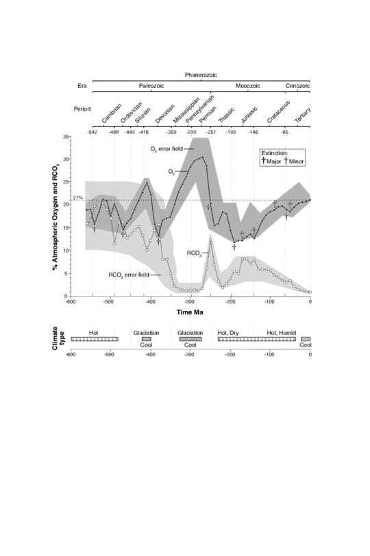
Oxygen content of the atmosphere over the last billion years. This diagram in more detail
The constant re-arrangement of continents by plate tectonics influences the long-term evolution of the atmosphere by transferring carbon dioxide to and from large continental carbonate stores. Free oxygen did not exist in the atmosphere until about 2.4 billion years ago during the Great Oxygenation Event and its appearance is indicated by the end of the banded iron formations. Before this time, any oxygen produced by photosynthesis was consumed by oxidation of reduced materials, notably iron. Molecules of free oxygen did not start to accumulate in the atmosphere until the rate of production of oxygen began to exceed the availability of reducing materials. This point signifies a shift from a reducing atmosphere to an oxidizing atmosphere. O2 showed major variations until reaching a steady state of more than 15% by the end of the Precambrian.[30] The following time span from 541 million years ago to the present day is the Phanerozoic eon, during the earliest period of which, the Cambrian, oxygen-requiring metazoan life forms began to appear.
The amount of oxygen in the atmosphere has fluctuated over the last 600 million years, reaching a peak of about 30% around 280 million years ago, significantly higher than today's 21%. Two main processes govern changes in the atmosphere: Plants use carbon dioxide from the atmosphere, releasing oxygen. Breakdown of pyrite and volcanic eruptions release sulfur into the atmosphere, which oxidizes and hence reduces the amount of oxygen in the atmosphere. However, volcanic eruptions also release carbon dioxide, which plants can convert to oxygen.[citation needed] The exact cause of the variation of the amount of oxygen in the atmosphere is not known. Periods with much oxygen in the atmosphere are associated with rapid development of animals. Today's atmosphere contains 21% oxygen, which is high enough for this rapid development of animals.

ATMOSPHERE

The atmosphere of Earth is a layer of gases surrounding the planet Earth that is retained by Earth's gravity. The atmosphere protects life on Earth by absorbing ultraviolet solar radiation, warming the surface through heat retention (greenhouse effect), and reducingtemperature extremes between day and night (the diurnal temperature variation).
The common name given to the atmospheric gases used in breathing and photosynthesis is air. By volume, dry air contains 78.09%nitrogen, 20.95% oxygen,[1] 0.93% argon, 0.039% carbon dioxide, and small amounts of other gases. Air also contains a variable amount ofwater vapor, on average around 1% at sea level, and 0.4% over the entire atmosphere. Although air content and atmospheric pressurevary at different layers, air suitable for the survival of terrestrial plants and terrestrial animals currently is only known to be found in Earth'stroposphere and artificial atmospheres.
The atmosphere has a mass of about 5.15×10¹⁸ kg,[2] three quarters of which is within about 11 km (6.8 mi; 36,000 ft) of the surface. The atmosphere becomes thinner and thinner with increasing altitude, with no definite boundary between the atmosphere and outer space. TheKármán line, at 100 km (62 mi), or 1.57% of Earth's radius, is often used as the border between the atmosphere and outer space. Atmospheric effects become noticeable during atmospheric reentry of spacecraft at an altitude of around 120 km (75 mi). Several layerscan be distinguished in the atmosphere, based on characteristics such as temperature and composition.
The study of Earth's atmosphere and its processes is called atmospheric science (aerology). Early pioneers in the field include Léon Teisserenc de Bort and Richard Assmann.

Structure of the atmosphere

Principal layers

In general, air pressure and density decrease with altitude in the atmosphere. However, temperature has a more complicated profile with altitude, and may remain relatively constant or even increase with altitude in some regions (see the temperature section, below). Because the general pattern of the temperature/altitude profile is constant and recognizable through means such as balloon soundings, the temperature behavior provides a useful metric to distinguish between atmospheric layers. In this way, Earth's atmosphere can be divided (called atmospheric stratification) into five main layers. Excluding the exosphere, Earth has four primary layers, which are the troposphere, stratosphere, mesosphere, and thermosphere.[7] From highest to lowest, the five main layers are:
  • Exosphere: 700 to 10,000 km (440 to 6,200 miles)
  • Thermosphere: 80 to 700 km (50 to 440 miles)[8]
  • Mesosphere: 50 to 80 km (31 to 50 miles)
  • Stratosphere: 12 to 50 km (7 to 31 miles)
  • Troposphere: 0 to 12 km (0 to 7 miles)[9]
Earth's atmosphere Lower 4 layers of the atmosphere in 3 dimensions as seen diagonally from above the exobase. Layers drawn to scale, objects within the layers are not to scale. Aurorae shown here at the bottom of the thermosphere can actually form at any altitude in this atmospheric layer
Earth's atmosphere Lower 4 layers of the atmosphere in 3 dimensions as seen diagonally from above the exobase.  Layers drawn to scale, objects within the layers are not to scale. Aurorae shown here at the bottom of the thermosphere can actually form at any altitude in this atmospheric layer

Exosphere

Main article: Exosphere
The exosphere is the outermost layer of Earth's atmosphere (i.e. the upper limit of the atmosphere). It extends from the exobase, which is located at the top of the thermosphere at an altitude of about 700 km above sea level, to about 10,000 km (6,200 mi; 33,000,000 ft). The exosphere merges with the emptiness of outer space, where there is no atmosphere.
This layer is mainly composed of extremely low densities of hydrogen, helium and several heavier molecules including nitrogen, oxygen and carbon dioxide closer to the exobase. The atoms and molecules are so far apart that they can travel hundreds of kilometers without colliding with one another. Thus, the exosphere no longer behaves like a gas, and the particles constantly escape into space. These free-moving particles follow ballistic trajectories and may migrate in and out of the magnetosphere or the solar wind.
The exosphere is located too far above Earth for any meteorological phenomena to be possible. However, the aurora borealis and aurora australis sometimes occur in the lower part of the exosphere, where they overlap into the thermosphere. The exosphere contains most of the satellites orbiting Earth.

Thermosphere

Main article: Thermosphere
The thermosphere is the second-highest layer of Earth's atmosphere. It extends from the mesopause (which separates it from the mesosphere) at an altitude of about 80 km (50 mi; 260,000 ft) up to thethermopause at an altitude range of 500–1000 km (310–620 mi; 1,600,000–3,300,000 ft). The height of the thermopause varies considerably due to changes in solar activity.[8] Because the thermopause lies at the lower boundary of the exosphere, it is also referred to as the exobase. The lower part of the thermosphere, from 80 to 550 kilometres (50 to 342 mi) above Earth's surface, contains the ionosphere.
This atmospheric layer undergoes a gradual increase in temperature with height. Unlike the stratosphere, wherein a temperature inversion is due to the absorption of radiation by ozone, the inversion in the thermosphere occurs due to the extremely low density of its molecules. The temperature of this layer can rise as high as 1500 °C (2700 °F), though the gas molecules are so far apart that its temperature in the usual sense is not very meaningful. The air is so rarefied that an individual molecule (of oxygen, for example) travels an average of 1 kilometre (0.62 mi; 3300 ft) between collisions with other molecules.[10]Even though the thermosphere has a very high proportion of molecules with immense amounts of energy, the thermosphere would still feel extremely cold to a human in direct contact because the total energy of its relatively few number of molecules is incapable of transferring an adequate amount of energy to the skin of a human. In other words, a person would not feel warm because of the thermosphere's extremely low pressure.
This layer is completely cloudless and free of water vapor. However non-hydrometeorological phenomena such as the aurora borealis and aurora australis are occasionally seen in the thermosphere. The International Space Station orbits in this layer, between 320 and 380 km (200 and 240 mi).

Mesosphere

Main article: Mesosphere
The mesosphere is the third highest layer of Earth's atmosphere, occupying the region above the stratosphere and below the thermosphere. It extends from the stratopause at an altitude of about 50 km (31 mi; 160,000 ft) to the mesopause at 80–85 km (50–53 mi; 260,000–280,000 ft) above sea level.
Temperatures drop with increasing altitude to the mesopause that marks the top of this middle layer of the atmosphere. It is the coldest place on Earth and has an average temperature around −85 °C (−120 °F; 190 K).[11][12]
Just below the mesopause, the air is so cold that even the very scarce water vapor at this altitude can be sublimated into polar-mesospheric noctilucent clouds. These are the highest clouds in the atmosphere and may be visible to the naked eye if sunlight reflects off them about an hour or two after sunset or a similar length of time before sunrise. They are most readily visible when the Sun is around 4 to 16 degrees below the horizon. A type of lightning referred to as either sprites or ELVES, occasionally form far above tropospheric thunderclouds. The mesosphere is also the layer where most meteors burn up upon atmospheric entrance. It is too high above Earth to be accessible to jet-powered aircraft, and too low to support satellites and orbital or sub-orbital spacecraft. The mesosphere is mainly accessed by rocket-powered aircraft and unmanned sounding rockets.

Stratosphere

Main article: Stratosphere
The stratosphere is the second-lowest layer of Earth's atmosphere. It lies above the troposphere and is separated from it by the tropopause. This layer extends from the top of the troposphere at roughly 12 km (7.5 mi; 39,000 ft) above Earth's surface to the stratopause at an altitude of about 50 to 55 km (31 to 34 mi; 164,000 to 180,000 ft).
The atmospheric pressure at the top of the stratosphere is roughly 1/1000 the pressure at sea level. It contains the ozone layer, which is the part of Earth's atmosphere that contains relatively high concentrations of that gas. The stratosphere defines a layer in which temperatures rise with increasing altitude. This rise in temperature is caused by the absorption of ultraviolet radiation (UV) radiation from the Sun by the ozone layer, which restricts turbulence and mixing. Although the temperature may be −60 °C (−76 °F; 210 K) at the tropopause, the top of the stratosphere is much warmer, and may be near 0 °C.[13]
The stratospheric temperature profile creates very stable atmospheric conditions, so the stratosphere lacks the weather-producing air turbulence that is so prevalent in the troposphere. Consequently, the stratosphere is almost completely free of clouds and other forms of weather. However, polar stratospheric or nacreous clouds are occasionally seen in the lower part of this layer of the atmosphere where the air is coldest. This is the highest layer that can be accessed by jet-powered aircraft.

Troposphere

Main article: Troposphere
The troposphere is the lowest layer of Earth's atmosphere. It extends from Earth's surface to an average height of about 12 km, although this altitude actually varies from about 9 km (30,000 ft) at the poles to 17 km (56,000 ft) at the equator,[9] with some variation due to weather. The troposphere is bounded above by the tropopause, a boundary marked by stable temperatures.
Although variations do occur, the temperature usually declines with increasing altitude in the troposphere because the troposphere is mostly heated through energy transfer from the surface. Thus, the lowest part of the troposphere (i.e. Earth's surface) is typically the warmest section of the troposphere. This promotes vertical mixing (hence the origin of its name in the Greek word τρόπος, tropos, meaning "turn"). The troposphere contains roughly 80% of the mass of Earth's atmosphere.[14] The troposphere is denser than all its overlying atmospheric layers because a larger atmospheric weight sits on top of the troposphere and causes it to be most severely compressed. Fifty percent of the total mass of the atmosphere is located in the lower 5.6 km (18,000 ft) of the troposphere. It is primarily composed of nitrogen (78%) and oxygen (21%) with only small concentrations of other trace gases.
Nearly all atmospheric water vapor or moisture is found in the troposphere, so it is the layer where most of Earth's weather takes place. It has basically all the weather-associatedcloud genus types generated by active wind circulation, although very tall cumulonimbus thunder clouds can penetrate the tropopause from below and rise into the lower part of the stratosphere. Most conventional aviation activity takes place in the troposphere, and it is the only layer that can be accessed by propeller-driven aircraft.

Space Shuttle Endeavour orbiting in the thermosphere. Because of the angle of the photo, it appears to straddle the stratosphere and mesosphere that actually lie more than 250 km below. The orange layer is thetroposphere, which gives way to the whitish stratosphere and then the bluemesosphere.[15]

Other layers

Within the five principal layers that are largely determined by temperature, several secondary layers may be distinguished by other properties:
  • The ozone layer is contained within the stratosphere. In this layer ozone concentrations are about 2 to 8 parts per million, which is much higher than in the lower atmosphere but still very small compared to the main components of the atmosphere. It is mainly located in the lower portion of the stratosphere from about 15–35 km (9.3–21.7 mi; 49,000–115,000 ft), though the thickness varies seasonally and geographically. About 90% of the ozone in Earth's atmosphere is contained in the stratosphere.
  • The ionosphere is a region of the atmosphere that is ionized by solar radiation. It is responsible for auroras. During daytime hours, it stretches from 50 to 1,000 km (31 to 621 mi; 160,000 to 3,280,000 ft) and includes the mesosphere, thermosphere, and parts of the exosphere. However, ionization in the mesosphere largely ceases during the night, so auroras are normally seen only in the thermosphere and lower exosphere. The ionosphere forms the inner edge of the magnetosphere. It has practical importance because it influences, for example, radio propagation on Earth.
  • The homosphere and heterosphere are defined by whether the atmospheric gases are well mixed. The surfaced-based homosphere includes the troposphere, stratosphere, mesosphere, and the lowest part of the thermosphere, where the chemical composition of the atmosphere does not depend on molecular weight because the gases are mixed by turbulence.[16] This relatively homogeneous layer ends at the turbopause found at about 100 km (62 mi; 330,000 ft), which places it about 20 km (12 mi; 66,000 ft) above the mesopause.
Above this altitude lies the heterosphere, which includes the exosphere and most of the thermosphere. Here, the chemical composition varies with altitude. This is because thedistance that particles can move without colliding with one another is large compared with the size of motions that cause mixing. This allows the gases to stratify by molecular weight, with the heavier ones, such as oxygen and nitrogen, present only near the bottom of the heterosphere. The upper part of the heterosphere is composed almost completely of hydrogen, the lightest element.
  • The planetary boundary layer is the part of the troposphere that is closest to Earth's surface and is directly affected by it, mainly through turbulent diffusion. During the day the planetary boundary layer usually is well-mixed, whereas at night it becomes stably stratified with weak or intermittent mixing. The depth of the planetary boundary layer ranges from as little as about 100 meters on clear, calm nights to 3000 m or more during the afternoon in dry regions.
The average temperature of the atmosphere at Earth's surface is 14 °C (57 °F; 287 K)[17] or 15 °C (59 °F; 288 K),[18] depending on the reference.[19][20][21]

Physical properties


Comparison of the 1962 US Standard Atmosphere graph of geometric altitudeagainst air density, pressure, the speed of sound and temperature with approximate altitudes of various objects.[22]

Pressure and thickness

Main article: Atmospheric pressure
The average atmospheric pressure at sea level is defined by the International Standard Atmosphere as 101325 pascals (760.00 Torr; 14.6959 psi; 760.00 mmHg). This is sometimes referred to as a unit of standard atmospheres (atm). Total atmospheric mass is 5.1480×10¹⁸ kg (1.135×10¹⁹ lb),[23] about 2.5% less than would be inferred from the average sea level pressure and Earth's area of 51007.2 megahectares, this portion being displaced by Earth's mountainous terrain. Atmospheric pressure is the total weight of the air above unit area at the point where the pressure is measured. Thus air pressure varies with location and weather.
If the entire mass of the atmosphere had a uniform density from sea level, it would terminate abruptly at an altitude of 8.50 km (27,900 ft). It actually decreases exponentially with altitude, dropping by half every 5.6 km (18,000 ft) or by a factor of 1/e every 7.64 km (25,100 ft), the average scale height of the atmosphere below 70 km (43 mi; 230,000 ft). However, the atmosphere is more accurately modeled with a customized equation for each layer that takes gradients of temperature, molecular composition, solar radiation and gravity into account.
In summary, the mass of Earth's atmosphere is distributed approximately as follows:[24]
  • 50% is below 5.6 km (18,000 ft).
  • 90% is below 16 km (52,000 ft).
  • 99.99997% is below 100 km (62 mi; 330,000 ft), the Kármán line. By international convention, this marks the beginning of space where human travelers are considered astronauts.
By comparison, the summit of Mt. Everest is at 8,848 m (29,029 ft); commercial airliners typically cruise between 10 km (33,000 ft) and 13 km (43,000 ft) where the thinner air improves fuel economy; weather balloons reach 30.4 km (100,000 ft) and above; and the highest X-15 flight in 1963 reached 108.0 km (354,300 ft).
Even above the Kármán line, significant atmospheric effects such as auroras still occur. Meteors begin to glow in this region though the larger ones may not burn up until they penetrate more deeply. The various layers of Earth's ionosphere, important to HF radio propagation, begin below 100 km and extend beyond 500 km. By comparison, theInternational Space Station and Space Shuttle typically orbit at 350–400 km, within the F-layer of the ionosphere where they encounter enough atmospheric drag to require reboosts every few months. Depending on solar activity, satellites can experience noticeable atmospheric drag at altitudes as high as 700–800 km.

http://en.wikipedia.org/wiki/Atmosphere_of_Earth#Principal_layers